Local trails:
This is the first in a series by Northword writer Morgan Hite featuring hiking trails in the mountains around the Bulkley Valley
Simpson Gulch (or Simpson’s Gulch) is a small, attractive gorge at treeline on Hudson Bay Mountain near Smithers, just north of the Hudson Bay Mountain Ski Resort. Easily visible from many points in the valley, it is sometimes called ”Little Simpson Gulch” to distinguish it from the large alpine canyon just north of it (which is actually nameless). Properly it is the smaller “gulch” which is Simpson’s: Donald Simpson and his brother were miners who staked and worked claims here between 1909 and 1926.
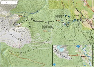
The “Simpson Gulch Road” was perhaps a track first built by Simpson Brothers to provide access from town to their claims. It was widened and “improved” after WWII by other miners. It continues today to provide a hiker’s route from the edge of town all the way to treeline (and the alpine “prairie” and Crater Lake area). If you want to start from Smithers and climb to the peak of Hudson Bay Mountain, this is your route.
Once in the Gulch there are many interesting things to explore, and one can easily spend two hours here. For an exit route up to the Prairie, follow the trail to its high point in the Gulch, then work up through the krummholtz and bands of rock.
Directions
At the north end of Railway Avenue in Smithers, cross the tracks and head directly uphill on Zobnick Road to where the pavement makes a hard right. There is a small trailhead here with a parking lot. Past this point, the trail is appropriate for non-motorized use only.
Pass through an old gate (sometimes locked) and proceed up the dirt road to the clearing for the hydro lines. Enter the clearing through a small spring-loaded red gate, and leave on the other side through a second red gate. Continue up the old road (which is now also a ski run connecting the alpine ski area to town). Pass around a final, grey gate about five minutes later. NOTE: After you pass through the final, grey gate, you are crossing private land for the next few minutes: please be respectful.
About 2.5 kilometres and 45 minutes along, and having climbed about 1000 feet, come to an intersection with a clearcut ahead to the right. (Another landmark here is the mountain-biking structures in woods to right.) Turn right, entering the clearcut (where many logs are stacked), and follow around its north side to find the old trail leaving at its northwest corner.
From here the trail continues for 3.75 kilometres and another 2000’ to treeline in Simpson Gulch. Allow three hours from the edge of Smithers to the head of the Gulch; two hours to return.

