Canyon Creek—Groomed trails, tree skiing, and alpine meadows
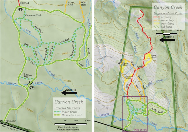
Canyon Creek Cross-Country Ski Area is about 25 minutes from Smithers up Babine Lake Road. The bottom section is groomed (although not set with tracks), while the upper section offers trails for backcountry touring and some opportunities for tree skiing.
Although the trail just barely reaches timberline (see sidebar), there is access to alpine meadows at the top. Tree skiing, indicated on the map, is through portions of an old 1934 burn where the trees are still widely spaced.
Being 500 m higher than the town of Smithers, the snow here can be in great shape, even when it’s melting in the valley bottom. From Smithers, head east toward Telkwa, and turn on Babine Lake Road, which you’ll take for 22 km. Pass the point where the road turns to gravel and the turn for the Canyon Creek Forest Service Road on the right. Look for a plowed parking lot on the right.
The parking lot is just before McKendrick Pass, at 1,040 m elevation. Groomed trails top out below 1,100 m, but ungroomed ones reach farther up this west-facing slope, through the old burn, and end just below 1,600 m on the ridge connecting Dome Mountain to Mount McKendrick. The trails are sponsored by the BV Outdoor Recreation Society, and maintained by volunteers. This will be their sixth year of operation. There is no fee.
Snowshoers are welcome, although they are asked to keep to the outside edges of the groomed trails and leave the middle for skiers. Dogs are also welcome, as long as their owners clean up after them. Firewood is provided at both picnic table sites.
See their web page at www.bcnorth.ca/canyoncreek/default.asp
Treeline and timberline
When I taught map reading in the U.S., a piece of folklore we told our students was the green areas on the topographic map indicated there was enough forest to hide a platoon of soldiers (about 40 people) per acre. It was a good way to explain why small clumps of trees didn’t appear on the map.
I like the implied subtext—cartographers producing the maps for military officers involved in some kind of domestic war, and needing to know where they could hide their men from aircraft—but it doesn’t take much reflection to realize that the U.S. Geological Survey couldn’t have visited all those places, looked at the tree cover, and decided where you could hide 40 guys.
According to Natural Resources Canada, the green area on topographic maps is “an area at least 35 percent covered by perennial vegetation of a minimum height of two metres.” And they probably estimate that 35 percent coverage from air photos.
So, when you’re ascending a mountain and the green ends on the map, is that treeline, or is it timberline? I’d always thought these were just variant terms for the same thing, but then I read Jim Pojar’s new book Alpine Plants of British Columbia. In the introduction, I learned that treeline and timberline are different:
The term treeline designates the upper limit of tree species occurrence, regardless of their stature, whereas timberline refers to the upper limit of continuous cover of upright trees three metres or more in height.
Timberline, being where the solid forest ends, is the end of green on the map. Treeline is the last little, twisted, stunted tree. And neither, of course, is really a line.


