China Nose: Northern BC’s Yellowstone
This is a stunning summit reached by an easy trail. China Nose is a remnant of a massive lava flow, rising gently from a forested south end to a shocking and exciting 400-metre cliff at its north end. Beware: the precipitous edge here lures you like a ramp that just continues, temptingly, into the sky. The area is dangerous because of its unfenced deadly drop, and fissures in the rock around the top are also potentially risky.
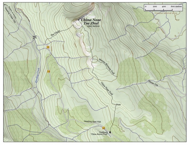
The trailhead is about 45 minutes from Houston, and the three-km hike up takes about an hour and a half, only climbing 160 m in elevation. Clip this map out and save it for a summer hike, or explore up there on snowshoes in winter. The trail is maintained by the newly formed Houston Hikers Society.
Sometimes the name is spelled “China Nose,” but in other places as “China Knows.” The BC Geographical Names Database recognizes both, with the latter explained by the enigmatic story that “the China[man] knows” where the gold is up there. For my money, though, the most descriptive name is the Wet’suwet’en: Tse Zhul, or “rock neck.” Its summit is at 1420 m elevation, just at treeline for this area.
Yellowstone National Park in the United States is famous for having been built by volcanic activity in the Eocene epoch, 50 million years ago, when lava and watery mixtures of ash and rock smothered the ground in volcanic breccias, agglomerates, basalt and tuff, hundreds of metres thick. We have the same thing here in north-central BC, where we call the result the Nechako Plateau—that vast, tumbled area between Houston and Prince George. At China Nose, a fat layer of those mixed flows lies exposed like a slice of cake.
Directions
From that unmistakable Houston landmark, the World’s Largest Fly Rod, drive 8.8 km east on Highway 16 to McKilligan Road and turn right. About 3 km later, pass the Houston Landfill and the road becomes the Heading Creek Forest Service Road: you are now at its km 0. The road is in good shape. Just after kilometre marker 12 it becomes the confusingly named “Heading East FSR” (confusing because it’s not heading east at all). It continues down over a little bridge (Heading Creek), then turns south. The trailhead is on the left in an old clearcut, just under 4 km past the bridge (note that kilometre markers more or less disappear after 13), marked with a brown wooden sign: “China Knows Trail.”
Initially the trail, which is well worn and easy to follow, heads up through an old clearcut. Once it reaches the uncut forest, it continues north along the gently rising back of the mountain, holding not to its centre but to its west side, where it links a series of small, dry, west-facing clearings. At one point, at a steep section on an outcrop of volcanic breccia, there is a handline, but it should be unnecessary in good weather.
After about an hour, the trail meets with another coming up from the east (marked “Maxan-Broman”). This trail comes up from a clearcut at the end of the Maxan-China Nose Forest Service Road on the east side of the peak. Where the trails meet there is a campsite, but no water.
Continuing north the trail goes up and down along the back of the mountain without gaining much elevation, then arrives at the sheer cliffs of the north end. Just before this, a tree, richly garlanded with flagging tape, marks the point where the Chute (also known as the Chimney) route joins from the left. This alternate route to the summit (perhaps it should be called “China Nose Direct”) begins from the road below, near the km 13 marker, and ascends steeply to the base of the cliffs. It then threads its way up to the top through a narrow, loose gully. In the gully a handline has been rigged, at one point, from a solid tree to help you pass a six-foot diameter chockstone. This route may be hard to follow from the road to the cliff base, but once in the gully you can’t lose it. The gully section is steep but not exposed.
On top of China Nose, it should be apparent to you that the mountain is falling apart: large columns are breaking off and the entire summit is riven with cracks. Be careful. Savour the view out over the Old Man Lake Provincial Park, and admire that great gulf of air.


Great article! I was always interested in the history of the mountain and how it got its name. I did hear about the “China(man) Knows” relating to the gold so my question is has there been anybody or expeditions on trying to locate the gold? Or is it just a folklore? Thank you
👤 Cody Gagnon 🕔 Sep 20, 2014