Photo Credit: Map by Nancy Alexander
Cranbrook Hill Greenway: Prince George’s greener transportation corridor
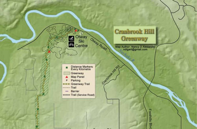
Greenways—a vegetation belt intended to maintain foliage while encouraging pedestrian use—are increasingly common in urban areas. In Prince George, Cranbrook Hill Greenway is a 22-km multi-purpose recreation trail for non-motorized travel that runs through forests along the city’s west edge, connecting Otway Nordic Ski Centre to the University of Northern BC (UNBC) and the Yellowhead Highway at Kimball Road.
Detailed maps are posted at Otway, UNBC and Blue Spruce trailheads with wooden distance markers every kilometre. The greenway is a trail corridor for walking, trail running, mountain biking, skiing, snowshoeing and equestrian use. This summer, UNBC First Nations students have constructed a pit house at one-kilometre.
Main access and parking lots are at Otway, Forests for the World and UNBC, and secondary access (with no official parking) is at Kimball Road and Westcrest Road gates. The topography is hilly with moderate slopes that can be challenging on skis in winter; creeks and wetlands are crossed on wooden bridges and sections of boardwalk. The views are forests of Douglas fir, spruce, poplar, aspen and birch.
From the Otway map display, follow the Greenway markers through the ski area trails. It’s flat for the first two kilometres to the old biathlon cabin and then climbs steadily to the ski area perimeter and a second greenway map display. From here, the trail continues to a ridge near 5 km that’s dominated by large Douglas fir. The next section includes the first boardwalk across a wetland and up- and downhill slopes through gullies and a stream crossing.
The only road crossing on the trail occurs at 8 km; about one kilometre west along the road is the gate at the end of Westcrest Road. Continuing south along the greenway, a picnic bench at 9 km marks halfway. Here the trail descends into a gulley, crosses the stream and ascends onto a pine-dominated ridge at 10 km, before crossing the stream again in two kilometres.
The last three kilometres to UNBC are perhaps the most eventful. The trail climbs steeply past a rock wall and cave. It continues to a long section of boardwalk around Labrador Tea Pond, dropping and climbing again to a ridge with a connector trail to Forests for the World and the highest point in Prince George. After crossing a lake outlet, you reach the highest point on the greenway before descending to the trail junction one kilometre from UNBC. The southern four-kilometre section to Blue Spruce Campground runs along a sunny ridge before it becomes a service road joining Kimball Road.
In winter, volunteers do grooming and occasional track setting, as needed. The Greenway Society, which is made up of representatives from local recreational groups, manages the trail and oversees activities such as trail clearing and fundraising.


