Forests for the World: A bit of Nature, nestled in a northern city
Forests for the World is a tiny bit of wilderness park embedded in the city of Prince George. With nearly 18 km of trails packed into about 1.5 square kilometres, it offers everything from a flat, short stroll to Shane Lake, where you can enjoy a picnic or a bit of fishing from its two docks, to a hilly challenge up and down the park’s western ridges.
From Prince George, Forests for the World can be reached by driving up Cranbrook Hill Road 1.4 km from the intersection with Foothills Boulevard and turning left (south) onto Kueng Road. From there, drive two kilometres to the end, where you’ll see the Forests for the World parking lot.
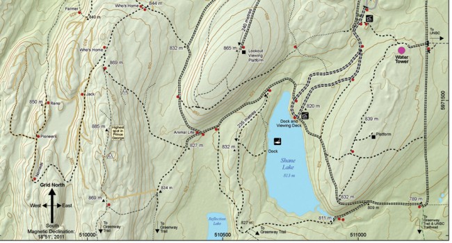
The trails begin on old roads and continue as single-track the farther you walk. As the single-track trails can be overgrown, keep careful track of your distances because it can be a challenge to see the junctions. So many trails in such a small park make for lots of twists and turns, and intersections that are close together. Whatever your trail choice, you can keep track of your location via the maps and markers located at many of the park’s trail junctions.
The Lookout Viewing Platform affords views across the city and, in the distance, the Rocky and Cariboo mountains. The ridge trail, including the “highest spot in Prince George,” offers glimpses north to the distant slopes of the Nechako River. The western-most trail, Who’s Home, climbs and descends one of several ridges found in the area. You can get a sense of the relief in the park by noting the “spot height” labels and contours on the accompanying map.
For an hour of steady walking (3.5 km) over lots of hills, you might enjoy following the Ridge Trail Loop. Begin from the north side of the parking lot and walk north along the trail marked for the Lookout (trail marker at gate). Keeping right at the next two junctions, watch for the trail along the ridge (labelled Highest Spot in Prince George on map). Keep left at each of the two Who’s Home panels and 50 metres along the trail the ridge proper is right at the next junction. You can return to the parking lot by following the trails just north of Shane Lake.
This 3.5-km loop’s hill climbs a total 120 metres (equal to about 40 flights of stairs). If you were to add the Who’s Home trail this will give you a total of 90 minutes of steady walking over a 4-km distance with 200 metres of total hills climbed (about 65 storeys).
If you prefer something gentle, from the parking lot it’s a level five- to seven-minute walk one way to Shane Lake. If you throw in a walk around Shane Lake, expect an additional 30 minutes and 50 metres elevation.
Forests for the World is truly a bit of wilderness in the city of Prince George: including bears, cougar and moose (so make lots of noise if you visit). Along with offering both exercise on its longer trails or just a short stroll to relax at Shane Lake, it’s also a great place for birding and checking out the wild flowers.


