Ganokwa Canyon Trail
Please note that as of summer 2017 BC Parks has officially closed the area past the Park Boundary on the Ganokwa Canyon route between November 1st and July 15th. This access restriction is for mountain goat conservation reasons. Please also be aware that this is an unauthorized route and therefore activities such as maintaining and marking this route within the park are not authorized.
- - - - - - - - - - - - - - - - - - - - - - - - - - - - - - - - - - - - - - - - - - - - - - - - - - - - - - - - - -
Many people were concerned about my publicizing this trail, so let me lead off by explaining why. The Ganokwa Canyon Trail goes into a zone of highly valuable habitat for mountain goats. This area on the edge of Babine Mountains Provincial Park has the “escape terrain” goats need, and because it faces south it is good winter habitat. In the Spring it is one of their natal areas, where the kids spend their first, vulnerable months of life. For these reasons, please use this trail only between July 15th and the end of October, which is when the goats have the option of dispersing into a wider area.
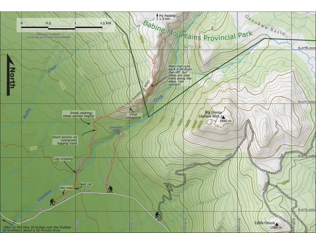
The unmarked trailhead is about 25 minutes out of Smithers, on Old Babine Lake Road just after it crosses Ganokwa Creek. To find it, I did something I’ve never done before: obtained a GPS track of the trail from the BV Backpackers, loaded it into a GPS, and drove, one hand on the steering wheel, one holding the GPS, to find it. I did feel rather like an idiot. But, after the 8 km marker, I crossed the Ganokwa Bridge, passed the gates of the School of Exploration & Mining on my right, and 0.8 km later there it was on the left: a small grassy clearing.
An old road led out of the back of the clearing, so I released Leo the giant golden retriever from the car, slung on my daypack and off we went. About ten minutes down that road (ignoring a number of forks to the left) we found an old, dead car. This is an important landmark, and we turned left here onto the actual trail, which shortly brought us to Ganokwa Creek.
Crossing the creek on a large and commodious log, the trail led us up a steep but short climb out of the creek bottom and then along the rim of the inner canyon—half a kilometre of lovely walking through mossy forest. Wandering away from the water for another half kilometre brought us to a small clearing.
We had climbed about 100 m of elevation from the creek, but now some serious climbing needed to happen if we were going to get up on the rocky ridge-top that ascends the north side of Ganokwa Canyon. This is where it began. I won’t sugar-coat this: the words unrelenting and merciless both occurred to me over the next 0.6 km as we ascended 230 m. If the School of Exploration & Mining ever teaches a course in switchback-building, re-routing this section of the trail would make a fine end-of-semester project for the class.
Eventually the slope began to mellow, and a series of viewpoints followed as we discovered we were atop the cliff band, and still climbing. It was the pay-off! Orange flagging tape also began to show up at this point, useful because there are fewer and fewer trees. You gaze across Ganokwa Canyon to the Big Onion, Ganokwa Creek roaring far below you, and the occasional crevasse opening in the bedrock indicates maybe you shouldn’t get too close to the edge. There’s a lot of exposure. Not a place for young kids. Unless you’re a family of mountain goats.
At this point you are entering Babine Mountains Provincial Park. The ridge continues upward, and the potential is there to hike on to the summit of Piz Padella (Padella Peak) and beyond.
Ascent to the park boundary is about 100 minutes, 3.5 km in length with a total climb of about 480 metres. The only water is at the creek. Perhaps bring a ski pole or walking stick for the descent.


