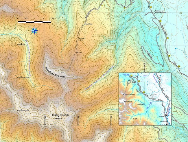
Photo Credit: Map Morgan Hite
Moonlight Mountain: A place for telling seasons
The alpine ridge that I was introduced to as “Moonlight Mountain” is a spur of the larger Kispiox Mountain, an arm flung out first north and then northwest to enclose the headwaters of one of the tributaries of Moonlit Creek.
On top of it, you are on the divide between the Kispiox and Kitwanga rivers. Down to the southwest, Moonlit Creek flows into the Kitwanga. To the northeast, where the trail comes up, are tributaries of McCully Creek flowing into the Kispiox.
This is not the only peak in the Hazelton area that gets called Moonlight Mountain. It’s a local, and certainly informal, name.
The forestry roads to the trail do not require high clearance, but it is a long way: 23 km up the Date Creek Forest Service Road from the Kispiox bridge and then six or seven km more up the twisty 2300 road. It’s about an hour from New Hazelton.
The trail (completely unmarked, but poke around on the uphill side at the road’s end and you’ll find it) is easy to follow and recently cleared (fallen trees sawed). It goes down across a creek and then ascends along the ridge heading south. It’s more or less moderate all the way, which is to say you’re going steadily uphill, but none of it is horrendously steep.
Although you drove up through cedar forest (the road flanked by piles of abandoned stacks of cut trees, perhaps from when Carnaby went under), you’re now in spruce-fir forest and you come to parkland (heather, smaller trees, openings) in less than an hour. Here the trail begins to disappear and at a couple places you notice other trails joining in from the side, places where it might be easy to choose the wrong path when you are returning.
After the parkland ends (note the small, pink ribbon on the last tiny tree) you are on a broad, ascending ridge of heather and grass. It narrows to a ridgeback, beyond which you come to a broad area at the base of the final climb up to Moonlight. This short-but-steep climb to the top is through finely bedded black rock (the strata tilted almost vertical) that shatters into tiny pieces. They are Bowser Basin sediments, the kind of oil and coal-bearing rock that has attracted geologists to the area between Hazelton and Spatsizi for years.
On top are splendid views. To the south, a ridge like a crescent dune connects Moonlight to the more massive Kispiox Mountain—high, orangey, dotted with permanent ice, draped with drippy lobes of scree, trimmed in patches of grass. An interesting bit of trivia to contemplate when gazing at Kispiox Mountain is that it is one of Canada’s 141 “ultras.” An ultra-prominent peak is one from whose summit you would have to descend more than 1,500 metres to walk to a higher peak. Other local ultras include Brian Boru, Mount Cronin, Howson Peak, Hudson Bay Mountain and the Seven Sisters.
It’s about an hour to the parkland, two hours to the highest point on Moonlight, and about an hour and a half down.


