Naydeena Mountain stunning views from “standing up alone”
Nadina Mountain Provincial Park south of Houston is large, hard to access, little-visited, non-motorized and has no facilities—but what a spectacular peak!
Unlike other mountains in the area, Naydeena (“standing up alone”) is a 2100-metre dome of quartz monzonite, a granitic rock that is blindingly white on a sunny day. Its curious location makes it is invisible from Highway 16. The peak is valued by the Wet’suwet’en people and is a traditional place to hunt caribou, marmot and mountain goat. Be prepared for a steep, rugged trail with spectacular views above treeline.
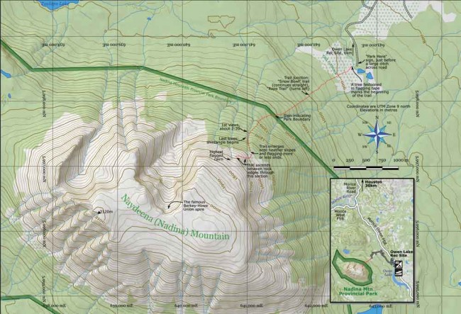
Take Highway 16 west from Houston to the left turn for Houston Forest Products, which is the start of the Morice River Road. Go straight at kilometre 27 where the Morice West FSR turns off to the right and turn right at kilometre 39 into the Owen Lake Rec Site. There are two dirt roads through the rec site, both leading to a bridge over Owen Creek. Cross this bridge and continue driving six kilometres to the parking sign for the Nadina Mountain trail. The road is fine for low-clearance, two-wheel drive cars to this point. You’re at about 860 metres elevation.
Walking, follow the signs for less than a minute to a tree festooned with flagging tape and the trail’s start. For the first 20 minutes, it goes through an old cut block full of bushes and mud holes, then into uncut forest. The trail ascends, steeply at times. You will pass a fork where the Rope Trail goes left; continue straight on the Snow Bowl trail.
After about 50 minutes, pass the BC Parks boundary sign. The trail is unmaintained and encumbered in places by deadfall, at times passing through tight forest, weaving creatively through the trees. At other times, it’s not unlike a staircase.
First views come after about an hour and 20 minutes, near 1400 m elevation. As the trees grow smaller, watch for flagging tape that continues to indicate the route. When there are no more trees, note your location and surrounding landmarks carefully. If you ever want to get home, you will need to return here to find the trail down.
Heather-covered slopes continue steeply upward. Because of the trail’s subtle change in direction just before treeline, the bulk of the mountain now lies up and to your right (southwest). Turn right and continue ascending. You may be lucky enough to find more cairns and ribbon for a while.
Heather gives way to grass interspersed with granite boulders. After about 1800 m elevation, even the grass gives out, but the higher you climb the more extensive the views. You can see from the Telkwa Mountains in the north all the way around to Francois Lake, Owen Hat and Ootsa Lake in the south. Morice Mountain is right across (although not as high). Owen Lake makes a snaky S-curve below.
Visiting the edge of the big cirque in the north side of the mountain is highly recommended. You may see the Berkey-Howe Union Spire, a rare, freestanding granitic pillar located at the head of the cirque.
Two cautions. The trail is dry: take water! Also, not disturbing goats is a priority. They mostly keep to the southwest side of the mountain.


