Seeking Robinson Ridge
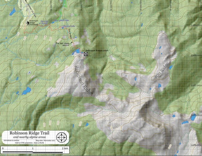
A plywood cabin tucked above an alpine lake sheltered by Robinson Ridge lures me away from the warmth of my home and laughter of my family. I gather my gear. My dogs wiggle, their noses nudge. I leave Terrace and drive south along Highway 37 towards Kitimat. The dogs’ noses press against one window and then the next, in anticipation. South of Hirsch Creek Bridge—57.5 km from Terrace and just one-half km before Kitimat—I take the first left onto Forest Avenue.
It’s a 14.5-km drive along gravel washboard to the trailhead. I firmly grip the steering wheel and the dogs bark at every new movement and scent. I drive straight ahead along the main road, past the log sort and the “No Dumping” sign. After this, I keep to the right at each fork.
I pass the brown signpost for Robinson Lake hike, the easier trail. I drive straight, following the sign pointing to Robinson Ridge. At 5 km, I cross a wooden bridge and pause to take in the waterfall. I drive in 4-high up the hill, still staying to the right at each fork. At 9 km I stop, put the truck in 4-low and crawl up the hill, cautious to avoid high-centering on a broken asphalt pad halfway up.
The road ends at the trailhead. I park, stretch skywards and admire the Kitimat Valley below. The trail is worn and easy to follow. In winter, snowmobile tracks create a well-packed trail for snowshoers. I don my pack, gaze up at the hill and start moving. I keep my eyes open for high-mounted yellow snowmobile signs and lower orange or pink flagging tape.
I cross a log bridge that wobbles under my step and enter a corridor of second-growth forest. I focus my camera on the sunlight streaking through the trees and know I have an exceptional image as I capture Cole dodging through sapling firs in chase of a squirrel. The trail opens up and ascends northeast through a mixture of swampy meadows, berry bushes and creek beds. At times the trail splits but always rejoins itself.
I see the first of three lily ponds, a landmark. But the trail is faint, easy to lose. I keep to the right of the first pond and to the left of the second and cross toward the right over a swampy meadow. The trail heads through an opening in the bushes from where I can see the third pond. I skirt the pond and ascend the hill beyond. I turn back for a moment to gaze at Douglas Channel far below.
After crossing a log bridge, the trail opens into a meadow with a blue-green lake. I turn right before the lake. Two steep sections follow. The trail opens into another meadow housing “Farina Lake.” I walk to the left, jump a small creek, cross the wet meadow and pick up the trail in the southeast corner. I follow a creek to the confluence of a second creek and a patch of skunk cabbage.
I approach “The Snake,” the most grueling section of the hike. Gathering my breath, I pause to admire the backside of Mt. Elizabeth to the northeast. Then I climb, and climb, and climb. I hear my heart thumping; my quads ache. At the top is a pond and the beginning of alpine with stunted trees, rock outcrops and white-flowered heather.
I stroll along; my pack feels light and Scooby and Cole bounce through the meadows. They’ve been here before. I ascend the last hill, move southeast and then dip down into a valley that ends at a pond. The trees open, a window to the larger lake and the ridge. I scamper down into the next valley, edge along the lake and turn left. I smile. The brown cabin above the second lake is nestled in the protection of Robinson Ridge.
Note: This is a wonderful trail to snowshoe, but in winter the road from Kitimat is not plowed. We rely on the goodwill of snowmobilers to take us to the trailhead, or we park 1 km along the road and trek up from there.


