Photo Credit: Morgan Hite
Seymour Ridge Trails
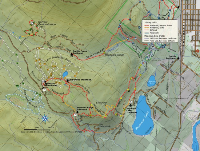
This is a wonderful set of trails that melt out early. Thanks to their location on a south-facing ridge, they can often be walked in April and certainly in May. They have great views and a few hidden gems: perfect for a spring hike. They offer several loops and the potential to walk down to the edge of town through the forest.
The Seymour Ridge trails are just one piece of a larger trail system within the Smithers Community Forest, established in 1991. The goal was to protect the cross-country ski trails and provide an outdoor classroom for the public to learn about forest management (check out the Harvest Demonstration Trail with its interpretive signs). Smithers Community Forest volunteers continue to maintain the trails.
There are four primary trailheads to access these trails, all reached by driving Hudson Bay Mountain Road out of Smithers. Seymour Lake trailhead is on your right 500 m after the orange “carry chains” sign. The Seymour Ridge trailhead is above the switchbacks at the seven-kilometre marker (hydro pole 85). Still higher, you can park at the Nordic centre, and enter the trail system via the Nature Trail and the backcountry Goldeneye Trailhead (very curious: a trailhead you have to walk to on another trail!). Or you can follow the logging roads in to the Dahlie Creek trailhead.
From the Seymour Ridge trailhead, follow the lettered signs along Seymour Ridge. The rough road you cross between A and B was put in recently by an adjacent landowner. If you go all the way to H, you can continue right down into town on the mountain bike trails Meanstreak and All Screwed Up (both are multi-use, but bikers have the right of way). They’ll bring you to the old Bug Block Road, which you walk down a short distance to R, and then along the boardwalk to the Duthie trailhead.
The Nature Trail is maintained by the BV Naturalists. They recently repaired all the boardwalks, and the interpretive markers and brochure have been upgraded.
One interesting feature along Seymour Ridge is the sackungen, visited on the newly-flagged alternate route between C and D. Sackungen are cracks in bedrock that occur when a ridge-top is spreading under its own weight. Fissures form, similar to the ice spreading on the surface of a glacier. The sackungen on Seymour Ridge are not crevasse-sized, but they are fun to visit.
The Waterfall Trail is a steep, stair-like trail, an express route to the top of the ridge, that takes you via a cascade that is likely to be booming in spring. There is no sign or parking where the Waterfall Trail leaves Hudson Bay Mountain Road but, as you are driving out of town, the trail takes off about 700 m after the Seymour Lake trailhead, where a small stream of water splashes out from the slope on your right. A large cottonwood tree grows just across the road from it.


