Photo Credit: Morgan Hite
Skilokis Ridge: Stairway to heaven
Skilokis Ridge is a remarkable trail that makes the claim to having you above treeline—on a spur of Blunt Mountain—in 30 minutes. It does it at the expense of some pretty steep hiking and an access road that screams, “Flat tire!” But it’s well worth the visit, even if you take your time on the way up and don’t make treeline for, say, 45 minutes.
From Highway 16, about 10 km east of Hazelton, turn onto the (unsigned) Suskwa Forest Service Road. The Suskwa FSR is a good road and you can do about 70 km/h, but watch out for the potholes. Just past the six kilometre marker, look for the smaller Skilokis Forest Service Road forking off to the right.
If the Suskwa FSR is an active road, the Skilokis is in the process of being forgotten. It’s in very good shape—no pothole dodging for you here—but you’ll find yourself reduced to 20 km/h or less. The next nine km will take you about 30 minutes.
Drive for more than five km on the Skilokis FSR, ascending through beautiful forest rich in cedar. At 5.5 km, you will come to a fork, just after the road descends for the first time. Bear right at the fork. Now kilometre numbering begins afresh, so soon you’ll pass kilometre one again. There are no high-clearance issues on this final section of the road, but for long sections its surface is sharp stones and you’ll readily picture your tires being put to the puncture test. You’ll feel more confident if you have a set of quite durable tires.
The trailhead is 9.1 km from the Suskwa FSR (about 3.6 km past that last turn you took), clearly marked on the left with a brown sign (“Skilokis Ridge”) on a pole. Can’t miss it. Pull over and leave passing room for any other vehicles that may happen by.
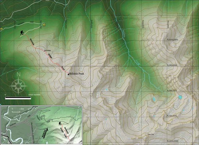
The trail is steep, but well worn and easy to follow, ascending through moss-intensive spruce forest. After 30 minutes, reach timberline (end of solid forest) and enter a parkland zone of heather, krummholz and lichen. After 15 minutes, there will only be a few scattered patches of krummholz ahead and you are effectively above treeline, with fabulous views in all directions.
The trail continues up the obvious, narrow, grassy ridge to the south. It’s not always obvious where it runs exactly, but you can keep finding traces of it by staying more to the ridge’s east side. The ridge is interrupted by a few little sags and the trail runs through the east end of each sag.
The ridge narrows to a knife-edge (but an easy-to-walk one) that leads up to the rounded Skilokis Peak. It goes up the steep final dome of Skilokis (intimidating, yes, but not as long as it looks) between scree fields: a ski pole or walking stick is a good idea here. And then you’re on top! To the south an interesting and inviting jumble of unnamed peaks continues on.
Allow two hours for ascent and 90 minutes down. This short trail is just over three km with 400 m elevation gained. It is dry! Carry water.


