Photo Credit: Morgan Hite • more maps at bvtrailmaps.ca
Suskwa Crossing: A bridge made of telegraph wire
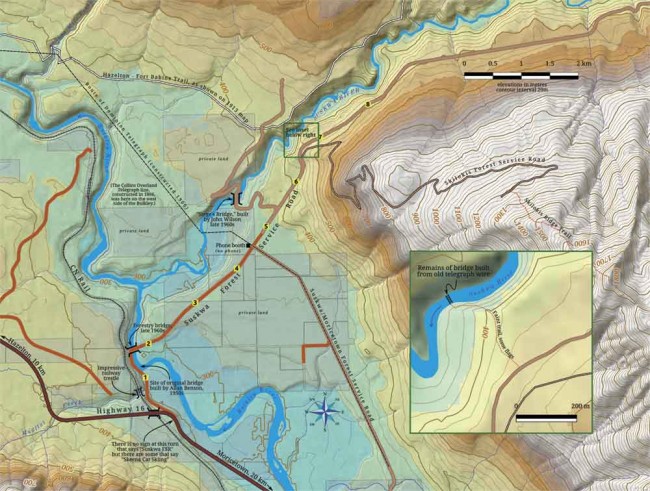
If you go down to the Suskwa River where it passes through a tight canyon some four and a half kilometres above its confluence with the Bulkley, you will discover the remains of a very old bridge, an airy span built from nothing but telegraph wire and wood.
A survey map from 1913 shows an “Indian Bridge” at this site. It makes sense: travellers coming down the Bulkley to Hazelton had the choice of crossing the Suskwa or using the log-and-rope cantilever bridge at Hagwilget that so terrified early Euro-Canadian visitors. Hagwilget Bridge was reinforced with surplus telegraph wire before it was replaced by an iron bridge in 1912. A similar kind of reinforcement seems to have happened with the Suskwa bridge in the late 1800s. But where did the wire come from?
The first telegraph line to come through the Bulkey Valley was the Collins Overland Telegraph in 1866. This line was supposed to run from New Westminster up through BC, Yukon and Alaska, cross at the Bering Strait and eventually go to Europe. The entire project was dropped when word arrived that a transatlantic cable had been laid. At this moment the telegraph-building crew had made it as far as Nangeese Creek, up the Kispiox River. Rolls of telegraph wire may have been abandoned at Anderson Flats (across the Bulkley from Hazelton), at Fort Stager (in Kispiox) and at Nangeese.
At the Suskwa, they used a lot of wire: the span is perhaps 30 metres long, with three main bundles of 15 wires each crossing the full distance (over 1000 m of wire in total). Planks were wired in to make a deck and longer poles ran along the sides. This may have been done by locals or it may have been a road crew sent out from Quesnel during the 1898 Yukon gold rush. Today, the wires’ anchors are hidden beneath moss, many planks are gone and you would definitely not want to try to cross this bridge.
There is no real trail to this fragile and historic bridge, but you can find it if you are willing to do a bit of exploring in steep terrain. Leave Highway 16 about 10 km east of Hazelton (20 km west of Moricetown) and turn onto the (unsigned) Suskwa River Forest Service Road. Cross the Bulkley and drive on to a point 300 m before the 7-km marker. Here the road climbs a hill and curves right, and on the inside of the curve are two old posts that used to hold a sign. Park on the outside of the curve.
Enter the forest on the north side of the road. If you find yourself in the vast, quiet, green, mossy cedar forest, you’re in the wrong place: you want a patch of mixed trees and bush. Bits of flagging tape of various colours have been hung up, some generally along the route, some not. There is a faint trail, and it heads down the crest of a small ridge. The route eventually drops steeply off this ridge to the left, just before you come to the water. The bridge spans the small gorge just upstream of where the trail comes down. Watch your step at the edge of the gorge!


Short but informative article Morgan. I wondered where that bridge was. I have seen a few BC Archive photos of the bridge including one apparently taken in 1961 see the Royal BC Museum Photo Archives photo # NA-20442. I have done a fair bit of research on the telegraph trail beyond this Kispiox walking some sections on the upper Skeena, upper Nass and near Bob Quinn. But I don’t know too much of the trail from Hazelton to Smithers other than what I have seen on a few old maps. I find the Yukon Telegraph story fascinating. Thanks again for sharing.
👤 Ken Newman 🕔 Apr 04, 2016