Take a Walk on the Hat: A bit of Bulkley Valley history
It seems that a regular theme of conversation among parents is what hikes they are now able to make with their children. In the Bulkley Valley one hears, “We made it to Crater Lake this year,” or “We made it to the top of Malkow Lookout.” Sometimes the kids get carried, sometimes they make it all the way under their own power, and in either case bug repellent is probably involved. But with the completion of this hike the family seems to achieve a new status of freedom and accomplishment.
So this month we have another route possible with young children, about the same length as those just mentioned, with a fabulous view and good picnic spot at the end.
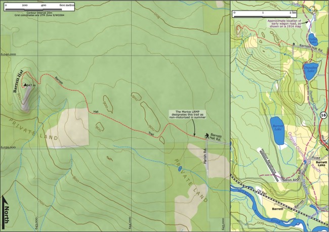
The Barrett Hat trail is an old road, about 3 km long. For the most part it winds its way through fairly level forest; then at the very end it finally gets serious, ascending 75m of elevation all at once. (This will be the part where the kids might get carried.) To get there, first find Barrett Hat Road, 13 km west of Houston on Highway 16, and just 2.4 km south of the Hungry Hill Summit. Drive in about 1.2km to a corner where the road turns left (and becomes Parish Road) and an old rutted two-track (that’s our trail) continues straight. Park here.
It’s 3 km (about 45 minutes) in to the Hat. Early on you go up through a small saddle, but after that the rutted old jeep road doesn’t change elevation much. Granted there aren’t many views on the way, and after rain the large puddles can be challenging, but in the end you climb the big plug of basalt that is the “hat,” spiralling up round it widdershins.
On top, near the abandoned foundation of what was once a fire tower, there are wonderful views in all directions. (The last switchback up to the summit is steep, rocky and loose. If you want to avoid coming back down it, there is reported to be a footpath from the east side of the summit, which leads north and down to the final turn before that switchback.)
You’ll notice that this neck of the woods is graced with many things “Barrett”: from the south side of the summit, you gaze down on Barrett Lake, and beyond that the site of the old Barrett Station. These are all named for Charlie Barrett, a long-distance horse-packer working for the Dominion Telegraph Line. He settled in the valley in 1901 and soon came to own a big ranch just south of Barrett Hat. The Diamond D Ranch was a major operation, encompassing several thousand acres, employing more than a dozen men in a time before Houston or Smithers existed. They specialized in packing supplies to the early mines in the Bulkley and Telkwa drainages, and sold meats, hay and other goods. Mr. Barrett lived here until his death in 1946. (As you stand on the summit, try picturing the valley before the coming of the Grand Trunk Pacific Railway.)
Although today’s chief method of travel, the highway, bypasses the old Diamond D as it leaves Houston, at one time the wagon road went right by its door. It was THE place to stay if you were travelling the valley, and it was famous for its parties. Once the railway was built, trains would drop mail for the “Barrett District,” and Mrs Barrett acted as postmistress.


