Photo Credit: Al Lehmann
Up the Clore: Shifting landscapes on a projected pipeline route
“Let’s go up the Clore,” one of the boys suggested one evening at yacht club—an informal weekly gathering at Terrace’s Back Eddy Pub.
Up the Clore. Something about those words resonated in me, a kind of venturesome buzz in the back of the brain, a suggestion of wild, high country.
“There’s great steelhead fishing up there,” one of the experienced anglers remarked. I could almost see a silver-bright fish flash behind his eyes somewhere.
Rob added, “And there’s a big slump on one of the slopes across the river from the logging road. I wonder whether or not it’s grown.”
Wow. Interesting news. The Clore Valley is a projected route for more than one of the recently proposed pipeline projects to access the Kitimat Valley. Unstable geomorphology could be quite a pipeline hazard, both during construction and especially during operation, when a slump could cause anything from foul diluted bitumen gushing into the river to a gas-sparked forest fire.
Three of us decided then and there to explore up the Clore to see what was happening for ourselves.
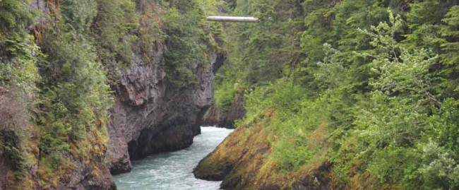
The Clore River is a secondary tributary of the Skeena River system. It rises high between the Kitimat and Morice ranges of the Coast Mountains, where surrounding peaks claw the sky at elevations up to 2,700 metres. Creeks fed high above by last winter’s snows and ice fields tumble into the valley where at high water the Clore rushes through forest and canyon to empty into the Copper (Zymoetz) River, Skeena’s direct tributary.
Companies have logged considerable swaths along the Clore, both down toward the river and higher up the rugged mountain slopes. But logging and construction on these slopes destabilize soil that is already precarious.
As trees are removed, root networks holding the land together lose their grip. Copious rainfall, exacerbated with freezing and thawing temperatures, pulls hundreds of tons of soil into the river, a phenomenon that occurs even without logging. Fishermen at the junction of the Clore and the Copper have often commented on the clearer Copper water upstream from the Clore’s inflow.
Shifting landscapes
At 10 a.m. Sunday, Jim swings his SUV into the driveway as agreed. I stuff a down vest into my pack, along with a make-do lunch and some bug spray. We roll over to pick up Andrew and within minutes we’re humming down Highway 16 toward the Copper turnoff.
Although we aren’t expecting industrial traffic, safety considerations make Jim do a radio call on the loggers’ channel. He repeats this at intervals as we head up valley, but no response—a good omen, we think.
Apparently no project is so demanding that our progress will be threatened by industrial traffic. Who wants to meet a loaded logging truck on a blind corner and get mashed into a rock bluff or forced over the edge into the river far below?
The road is surprisingly smooth. I mostly listen as Jim and Andrew talk of pulling steelhead from nearby riffles. Jim has fished the Copper for over 35 years and Andrew has been all through the valley seeking fishing adventure since he arrived in the area over 20 years ago. I don’t fish, but I’m fascinated by their fascination.
At about 17 km we pass a U-shaped rip in the mountain wall to our right. A torrent of creek water sheets out into a pool 20 feet below, splashing noisily and casting rainbow light from its dancing spray.
This is the site of a 2005 landslide, when a great chunk of mountain peak broke away and thundered downslope into the Copper Valley, temporarily damming the river, smashing through a gas pipeline and starting a forest fire. The remains of the temporary lake its sudden dam created still soak the dead roots of a significant copse of trees whose skeletal branches decorate the landscape in a macabre way.
Twenty minutes later we reach the Clore confluence and, turning right, head up its valley.
The road along the Clore rises rapidly. Within only a few kilometres we’re hundreds of feet above the river, winding steadily upward around ridges and outcrops.
Sure enough, visible across the valley is the slump Rob mentioned, a great scar on the slope where hundreds of tons of rock and clay broke away from the valley side and scoured downward, mowing timber like grass and leaving a boulder the size of a small house settled at the bottom.
“Yep, it’s gotten bigger,” Jim comments.
Enduring mountains
A dozen kilometres farther we encounter a young native woman in a 4x4 employed by a First Nations logging company to keep an eye on expensive machinery. Muted country-and-western floats out her window to be lost in the mountain vastness. She looks at us speculatively and at first is reluctant to approve our passage.
“This is a public road,” Andrew points out. “Isn’t there someone you could call?”
She quietly retrieves a radiophone from beside her and generates a connection to someone in authority.
“Tell them it’s Jim Culp,” says Jim, a legend in the local fishing scene.
She might as well have said, “Open sesame!” Only moments later we’re bumping past a number of large machines, part of an ongoing logging operation.
“Nice work, isn’t it,” someone comments ironically, pointing at the logging waste.
Still, despite any damage, the surrounding peaks seem to gaze on with indifference. “They’ll be here long after we’re gone,” I think.
Past the current logging, at an old clear cut, we leave the truck to hike up the narrowing track through bush alder. We chat loudly, having seen bear scat only a few hundred metres down the trail.
“Anyone got any bear spray?” someone asks. No response.
At that moment we hear the punctuated grumble of motors behind us. A minute or so later three quads pulled up beside us.
“We’ve come over Telkwa Pass,” one of them offers. “Know where this waterfall is?” he points to a Google Map on his GPS.
“No,” we concede. “We’re just heading back down to the truck,” Andrew adds.
At the truck we turn back upslope to see the quads hightailing it back toward us.
“There’s a big griz up there,” one of them explains, trembling slightly, then showing us the massive brown animal he’d snapped with his iPhone. “We fired a banger at him? He just stared at us.”
Our return to the truck was a wise decision.
Once in the truck, we wind back down the valley, past the lonely woman at her vigil, watching the quads’ dust cloud dissipate ahead of us. We’re quiet, locked into our own thoughts.
The Clore Valley is fabulous, rugged, steep and mostly wild. I pictured it crawling with foreign workers and heavy machinery, everything ant-like on the heavy slopes, trying to construct some precarious pipeline toward the peaks of the Kitimat Range. It was disturbing to imagine, a preposterous vision of hubristic stupidity.
At the confluence we stop to look at the gush of Clore water roiling out of the canyon and down to the Copper. A touch of rain spits at us and a breeze riffles the alders along the bank. It’s clean and wild and beautiful—for now, at least.


