Photo Credit: Morgan Hite
Where do I Find a Trail Map?
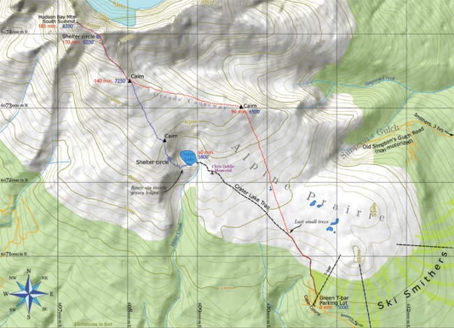
Call me old-fashioned, but I prefer a paper map. You can fold them any way you want, you can draw on them, and you can unfold them so they’re really big. Moreover, they shine when the batteries in your iDevice turn out to be dead. So, this month, I thought I’d survey where you can get trail maps across the North.
Trails to Timberline by Einar and Andrew Blix, now in its third edition (2009), is the master reference for trails between Kitimat and Houston. The maps are the old topographic maps with the trail drawn in. The Central Interior Trail Guide (in two volumes) by Carson, Nelson and King covers the area near Prince George and the Robson Valley, as does Rob Bryce’s Hiking North Central BC. Matt Simmons’s Outsider’s Guide to Prince Rupert has lovely maps by Alyssa Parker.
On the web there are a lot of maps that you can download and print on an ordinary printer. Check out Houston Hikers (houstonhikers.ca) for 16 maps of trails in the Houston area. BV Backpackers (bvbackpackers.ca) have 13 for the Bulkley Valley. Maps from the Local Trails column here in Northword can be downloaded at hesperus-wild.org/GIS_carto/BVTrailMaps.html.
If you are going to a BC Park, env.gov.bc.ca/bcparks often has a park map you can download, once you go to the page for the specific park. Note that these maps are often more schematic than topographic. Similarly, pages for specific sites at Rec Sites and Trails BC (sitesandtrailsbc.ca) may host a printable map: this is true, for example, with the hike and bike trails of The Bluff in Smithers. The city of Terrace has a Trails and Rec Sites page (terrace.ca/residents/leisure_services/trails_rec_sites) with maps of local trails for download.
Maps in the Backroads Mapbook for Northern BC are small-scale (1;250,000), so more useful for locating a trailhead than following the trail itself. Unfortunately these maps suffer (as do the Outdoor Recreation Maps that Backroads Mapbook publishes on nice waterproof paper) from quite a few errors. They’re very attractive, with their shaded relief, but sometimes it seems they just weren’t field-checked. Stray lines that seem to be roads climb ridges where no road goes, and trailhead symbols suggest infrastructure (such as parking lots and trail signs) in places where, in fact, there is naught but a bit of faded ribbon in a tree by the road’s edge. Use these with caution!
You can still buy the familiar NTS (National Topographic System) 1:50,000 and 1:250,000 scale topographic maps. Interior Stationery in Smithers, for example, sells them. Most of these maps haven’t been updated since the 70s, but while current trails and roads may not be on them, the topography itself hasn’t changed.
If you like a really large-scale map, Clover Point Cartographics (canadamapstore.com) prints a beautiful series of 1:20,000 maps from current data. The detail is fantastic and features are generally up-to-date, but they are pretty expensive (about $21), and each one is so local that you may find you need to buy a whole library of them.
If you like to play with printing your own NTS topo maps, these are all available online for free at ftp2.cits.rncan.gc.ca/pub. There are different formats to choose from. CanMatrix are TIF images of the maps; if you happen to have a giant plotter lying around you can print the whole thing, but even if you only have a little printer, you can use a photo program to cut a piece out of the whole and print that. CanMatrix2 (or CanMatrix PrintReady) is a PDF or TIF of the map, but twisted slightly to square it on the page. Toporama is a TIF image of a 1:50,000 map that has been automatically generated from the latest data; it’s not pretty, but it’s accurate. CanTopo is the new generation of topo maps, but these have been produced for only a few places in Canada so far.
So leave your GPS and phone at home. Grab a real map, and go low-tech!


