Glacial melt’s chilling implications for water resources
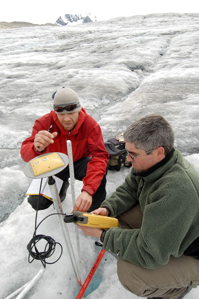
Last summer, student Matt Beedle stuck a pole in a glacier. The research technique may not sound like cutting-edge science, but the result was unequivocal: Nearly a month later, the pole, which had only a few millimeters showing when he planted it, was exposed nearly to his 5’11” height.
Was he surprised at the results?
“Ah, no,” admits the UNBC doctoral student. In fact, GPS technology on the Castle Creek Glacier near McBride confirms the prehistoric ice mass is dwindling between three and five metres in thickness near its terminus every summer. Shrinking along with it are the North’s vast and valuable water resources.
Apart from pole-planting and GPS technology, the Castle Creek Glacier provides a unique opportunity for studying glaciers in Canada. For the past 50 years, the glacier’s annual push forward, followed by a greater recession, has created a series of moraines that map the glacier’s history like tree rings, something only ever seen before in Iceland. Combined with aerial photographs and satellite imagery, the moraines provide one of the best records of glacial change in North America.
Although this bodes well for scientific investigation, the research doesn’t indicate a bright future for northern BC’s water resources.
“In all likelihood, things will keep receding—glaciers will keep receding—with negative impacts on water resources across the province,” Beedle says, adding that glacial recession has particular implications in the North. “We have watersheds up here where we have a huge amount of glaciers which, as they melt, could have big implications for salmon and most other things.”
Beedle’s work examines glacial change in the Cariboo and northern Rockies, two regions in the North that haven’t previously been studied. He is part of a larger group of 40 to 50 researchers undertaking a five-year program throughout the province, funded in part by BC Hydro, that looks at the glaciers’ impacts on water resources. When the study wraps up next year, it’s hoped that the research will provide a model for managing water resources in the future.
Glacier inventory
The research piggybacks on the work of post-doctoral UNBC student Tobias Bolch, who recently produced the first detailed inventory of glaciers in BC and Alberta. The research has opened the door to more detailed glacier studies in the area, and Beedle admits it’s surprising the work wasn’t done earlier.
“It’s kind of a jumping off point for the entire network of researchers, this basic inventory of all the glaciers that are in BC and Alberta,” Beedle says. “It is shocking that it hasn’t been done, but to be quite honest with you, we don’t know how many glaciers there are or how big they are. We have a rough idea and it’s getting better all the time with more and more satellite imagery available, but there’s still a lot of work that needs to be done.”
The project reconstructs glacial change since the maximum extent of the Little Ice Age more than a century ago, when the glaciers pushed up massive moraines at their farthest extent. A combination of moraine and air photo analysis indicates that the glacier has retreated an averaged of about 14 metres per year; at least as far back as 1946.
Recession came almost to a standstill at the Castle Creek Glacier, which lost only about three metres each year, during a cold spell during the 1960s and 1970s, while some glaciers actually advanced during this period. This was followed by a significant rise in temperature and corresponding increase in recession during the late-1970s, with glaciers retreating up to 20 metres each year.
Then, in the early 1990s, melting spiked with recession almost three times what it had been in previous decades, reaching an annual maximum of 42 metres in 1992.
“It’s been pretty shocking to see. We’ve actually found this spike has occurred in other glaciers in northwestern North America,” Beedle says. “Honestly, we don’t know why they all peaked in 1992. To have glaciers that far removed from one another changing so dramatically at the same time leads you to assume there’s a common driver of that.”
Colder phase
Cooler, damper weather the past few summers has been good for glaciers. A full decade of similar conditions could see glaciers begin to advance again, “but I would say that’s unlikely,” Beedle adds. “We would need to see conditions like the last couple years where we had a super rainy, cold summer and big snow years. We would need that for at least a decade, if not 15 or 20 years.”
Circulation patterns in the North Pacific, which have been in a colder phase since 1998, will likely cast similarly cooler weather on the region for another decade; that cooling trend, however, is superimposed on generally increasing global temperatures, Beedle says. Once the area switches back to a natural warming phase, the weather will be “dramatically warmer,” he adds.
To what extent these climatic changes are natural or human-caused is the “million-dollar question,” Beedle says, but the implications for water resources could be significant, particularly away from the coast in areas like the Peace and Robson Valley that rely more heavily on melt water.
“Glaciers are very unique in that they’re this independent monitor of climate, independent from temperature stations around the world,” he says. “Studying them gives us this independent measure of what’s going on and the fact that they’re melting all over the world—there’s very few examples of any glacier advancing—shows that this warming is indeed global and provides independent confirmation of this global change.
“If you look at it globally, in terms of water issues, it is a big issue, and very disconcerting.”

