The Blue Lakes Trail
This trail was originally constructed in the 1920s as a pack trail to the Black Prince and Blue Lake claims near the upper Blue Lake. At that time the trail would have begun down on the flats near the highway, but that section was obliterated by clear-cut logging. The present trail starts at a higher point and ascends through the remaining intact fir forest.
Note that Mudflat Creek has no identifying sign where Highway 16 crosses it, and there is no sign for Mudflat Creek Road. It is about 2 km north of the Suskwa River Rd turnoff (itself no longer signed). This is about 60 km north of Smithers.
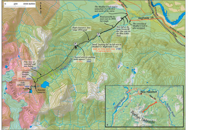
Once on the narrow deactivated road there are very few places to turn around and occasional ruts require you to drive slowly. The pull-out for 2WD vehicles can be recognized by the presence of a second yellow Deactivation sign, but it is well worth bringing a vehicle that can get to the final parking lot, since it cuts 2km and 300m of ascent off the hike. This part of the road is uneven; passengers and possessions are thrown about inside the vehicle. You may be able to offer a ride to hikers you find walking.
The trail ascends gradually for 2 km through rich forest, then in the next 2 km it crosses a series of five avalanche tracks thick with salmonberry in the late summer. At this point you leave the conventional rock of the Bulkley Valley and enter the “Bulkley Plutonic Suite,” a delightful white, granite-like, igneous rock that forms the core of the Rocher Deboule Range. After crossing a short boulder-field, note a side-trail on the left to the waterfall campsite, complete with two picnic tables and a badly porcupine-chewed privy.
At the upper lake the trail continues around its north side to an improved campsite nestled in krummholtz (again with massive picnic table); however there are many other attractive places to pitch a tent. From here the way is clear to access higher portions of the range.
Directions
Turn onto the Mudflat Creek Road, 8 km south of Hazelton on Highway 16. In less than one kilometre, turn left onto a deactivated road at a brown BC Rec Site sign on left for “Blue Lakes.” Most 2WD vehicles can proceed slowly for about 2 km to a small pull-out on the left beside the creek (elevation 700m). High-clearance 4WD vehicles can proceed another 2 km to a larger parking area at the trailhead (elevation 1000m).
From here the trail ascends 400m over 4.25 km to the upper Blue Lake and treeline. Allow 2.25 hours up, 2 hours down. Add an hour each way if using the lower parking spot.

