A quick jaunt in the Quick Hills
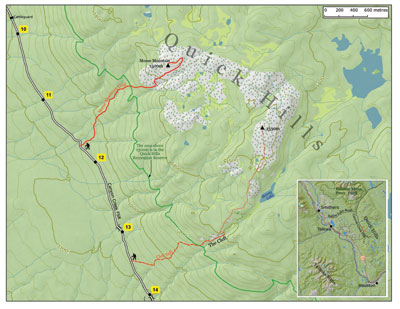
This is a pair of trails into the Quick Hills, a delightful area of rock outcrops and a sparse forest near 1500m elevation, the edge of treeline for the Bulkley Valley. The Moose Mountain Trail is short (the hike up takes only about an hour), easy to follow, and leads directly to the rocky summit of the same name. The Cleft is more of a challenge: initially it’s a trail (into the Cleft), after which what would be more accurately described as a “route” (navigation and route-finding required) goes up onto a series of knobs and outcrops with good views. It should be possible to do a loop by linking this route with the Moose Mountain trail. This is a popular snowshoeing area for Quick residents!
To get to the trailheads, turn north off Highway 16 onto Babine Lake Rd, 4 km east of Smithers. At km 19.5, about 4 km after the pavement ends, turn right onto the clearly marked Canyon Creek Forest Service Road (FSR). Throughout its length, this road is in good condition and is posted with yellow kilometre markers.
The Moose Mountain trailhead is at km 11¾, marked by a brown post on the left (east) side of the road at the top of a rise. (You are about 35 minutes from intersection of Hwy 16 and Babine Lake Road at this point.) The Cleft trailhead is marked by a similar post at km 13.5, where the road is going through a long, straight descent.
Moose Mountain Trail. For most of its length, this trail follows an old cutway about 10 feet wide through spruce-fir forest with the occasional pine and alder. The trailbed is well-worn and easy to follow on the ground; in winter, snowshoeing, you can follow its wide swath. The cutway crosses a creek early on, and then works its way diagonally left up the slope to another creek, which it follows up and crosses three times. It then diagonals back to the right across the slope towards the first creek.
Now the cutway continues up the creek into the summit area, but the trail turns left onto rocky outcrops, and parallels the cutway higher up, passing right under the summit, which is a large whaleback of exposed rock. The trail goes to the east end of the whaleback before doubling back along its top to the high point, where there is a survey marker.
Cleft Trail.
For the first 1.5 km there is a trail into the Cleft. However this is more of an “advanced” trail: it is not difficult, but tricky to follow, being hardly visible on the ground. It is marked in the trees with dark red flagging tape sporting a black stripe or black dots, or at times just orange flagging tape. It works east across the slope through the forest, sometimes turning north and ascending. Just as you arrive at the Cleft and rock faces begin to appear uphill on your left, the trail loses itself in meadows. If in doubt, follow your compass East, and travel up next to the creek. From the Cleft you can scramble up onto the rocky outcrops to the left, and then make your way northeast and north along a broad, treed ridge, visiting a series of successively higher outcrops, to a summit. In summer it’s preferable to bump up and down along the ridgetop and avoid the wet meadows; in winter the opposite holds, as the meadows make for the easier travel.
Winter access to these trailheads depends on how far the Canyon Creek Rd is plowed, which in turn depends on where logging is taking place. Note that a cutblock is being planned at present in the Cleft trail area.

