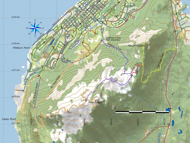
Photo Credit: Map by Morgan Hite
Mount Hays
Mountains and oceans are like bacon and eggs—they just work well together. Anywhere you can hike up a peak to get a view that includes endless ocean vistas, you know you’ve hit the jackpot.
In Prince Rupert, that’s the mainstay—if the weather cooperates, of course.
Mount Hays lurks over the coastal city, dominating its weather patterns and enticing hikers. It’s only 700 metres in elevation—which, in some circles, would make it a “hill” not a mountain—but those metres come quick when you’re slogging up the steep slopes. The UN says a 300-metre gain in less than seven kilometres means it’s a mountain. Rupertites just know. Anything that creates its own weather is a mountain in my books, and Mount Hays is a perfect example.
It’s also a great hike. The Kiwanis Trail is a local favourite, but be warned, it’s really easy to lose your bearings up on the plateau. Local search and rescue has been out on many occasions tracking down lost hikers up there.
To get up to the peak of Hays, you’ve got a few options. You can take the Tall Trees Trail (recently restored to its former glory) up to the peak of Mt. Oldfield and connect over to Hays from there; you can walk up the road—a grunt for sure, but you still get the views at the top; or, you can climb the Kiwanis Trail.
Kiwanis takes you straight up from the Oldfield Creek Fish Hatchery on Wantage Road, past the remnants of an old reservoir. There are cliffs, waterfalls, and impressive stands of old-growth trees. For the first few kilometres, the trail is easy to follow, but it gets harder as it makes its way up the mountain. In the open muskeg glades, look carefully for flagging or blazes and stick close to the map. On the ridge, there are remnants of an old ski area: wooden signs, huts, and cabins. The trail leads to a small pond, once a turn-around point for cross-country skiers.
This is where you can connect over to Mt. Oldfield, by skirting the pond on its northern shore and climbing up the opposite hill. To continue on the Kiwanis Trail, head southwest (right) along the pond’s shoreline and pick up the flagged route. It follows the long ridge to the southwest, climbing steadily towards the summit.
Eventually, the trail emerges at the lower communications towers. To reach the actual summit, continue up the road a further 850 metres. This is a long, wet trail in the true Rupert spirit: gumboots or gaiters are essential.

