Photo Credit: Morgan Hite
Onions, Little and Big
You may not have heard of a peak in Slovenia named Triglav, but you can be sure that Slovenians have. As the highest peak in the country, it is a goal for many Slovenes to climb it at least once in their lives. What if we had a similar tradition in the Bulkley Valley, that once in your life you would make an attempt to climb... the Big Onion?
Visible from almost everywhere in the central valley, the Big Onion is an accessible, colourful, dome-shaped peak with a broad summit that stands east of Smithers. Imagine the pride and pleasure you might get as you gaze at it from Highway 16 and muse, “Yep, I’ve been up there.”
Although it’s right next to Babine Mountains Provincial Park, the mountain was excluded from the park so its valuable minerals might someday be mined. This is in fact where its name comes from (rather than from any resemblance to a vegetable). Joe L’Orsa’s History of the Babine Mountain Recreation Area says, “In 1917 Axel Elmsted and his partners Tommy Haig and Ben Benson found mineralization on a mountain which they then named the ‘Big Onion,’ after Ben Benson’s habit of talking about ‘peeling the onion’—striking it rich. This onion was the BIG one.” They staked the property the following year, and even today the scars of prospecting and exploration on the bright orange sides of the peak are visible from a distance.
“Big Onion” is not an official name as far as the province of BC is concerned. The province recognizes only the name of the westernmost and highest of the three prominences that make up the Big Onion: Astlais Mountain, elevation 1841 metres.
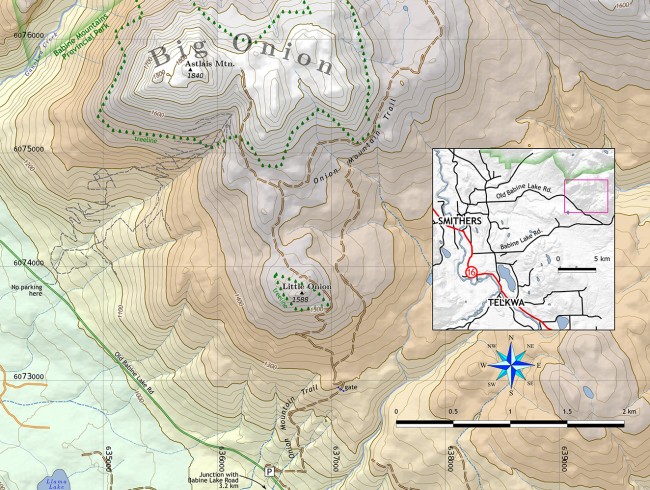
The small prominence to the south that pokes up above treeline is colloquially called, by association, the Little Onion. It makes a nice destination for a half-day hike, being about an hour and a half from the trailhead.
Approaches to both Onions are straightforward. There is a large parking lot on Old Babine Lake Road, about 3.5 km from its junction with (new) Babine Lake Road. This lot is at the base of an old mining road, variously called the Onion Mountain Trail or the Little Onion Trail. It runs up and over the Little Onion, and on around the Big Onion and into Babine Park. A spur leads up to the saddle between two prominences on the Big Onion.
From the parking lot, the old road is steep and there is no reliable water. It switchbacks up through an old burn and then splits in the forest above (take the left fork). At the Little Onion, be sure to leave the road for a moment and climb to the high point just to your west. It’s an excellent stop for a break, and having ascended 500 vertical metres to the lesser Onion you have only 300 more vertical metres to go to the top of the big one.
Past the Little Onion it’s just under one km to a second fork where the Onion Mountain Trail heads right. You go left, into the maze of exploration roads at the base of the Big Onion. The only one of these that you are interested in is the very steep one straight ahead, that goes up to the saddle between Astlais and the middle prominence. Ascending through multi-coloured hues of orange and yellow screes, this remarkable road provides a solid, if dry, staircase to the grassy saddle.
From the saddle, climbing turf and heather to the summit cairn on Astlais takes about fifteen minutes. From here you get impressive views of Ganokwa Basin and the southwest half of the Babine Park. The Little Onion is certainly the way to approach this peak: I don’t recommend getting to (or from) the base of the Big Onion via the labyrinth of bulldozed roads that occupy its southwest side. New scrapes overlap older scratches, which in turn overlap older trails, and the whole mess is confusing and complex. I’m not even sure it’s shown correctly on the map above. And there’s nowhere to park at the bottom.
Be sure to carry water on your once-in-a-lifetime ascent of the Onions!
For more maps, go to bvtrailmaps.ca or email morgan@hesperus-wild.org.

