Photo Credit: Morgan Hite
Sinclair Plateau
Lost? You want to get lost? I’ll tell you how to get lost. I have the place for you.
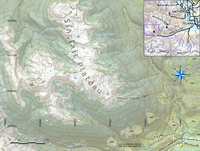
The Sinclair Plateau is a trail-less area above treeline somewhere up the Telkwa River. It’s a famously confusing place…to find your way out of.
Starting from Telkwa, zero your odometer on the bridge over the Bulkley River and continue out of town on Coalmine Road. Just before 6 km bear right (where Aveling Coalmine Road goes left). This is kilometre 0 on the Telkwa River Forest Service Road, also known as Road 1000. Just before 9.5 km bear left (a sign proclaims this the beginning of Road 1000). From here the potholes are bigger and the surface of the road is noticeably looser.
On your way to 1028 km (24 km ahead) you cross the Telkwa River, pass the Telkwa Ponds Rec Site, and a series of statements regarding caribou management and snowmobiles (“sleds”) that have been painted on sheets of plywood bolted to roadside trees. I encourage you to draw your own conclusions.
It takes just over an hour from Telkwa to get to the parking spot—I hesitate to call it a trailhead. After the 1028 km marker, take the right turn that heads uphill off the FSR (there is an avalanche warning sign here). This narrow road leads to yet a narrower road when you are 1.8 km in: turn right here. It’s hard to believe this is the correct place until you come to signage specifying summer non-motorized and winter motorized use. Parking is just ahead, before the deactivation ditch and creek; it’s almost too narrow here between the walls of alder to turn around, so I recommend parking some 100 m back, where there is more space to reverse.
On the other side of the ditch the road continues, a very pleasant walk, and indeed, eminently bike-able if you want to try that. The road is in excellent shape up to the point where, in an old cut block, there is a small brown arrow sign, and the trail begins in earnest. It’s just over 2 km to this point.
The trail is wide at first, allowing you to continue to walk side by side with your hiking companion. The track continues to the upper edge of the cut block where signs confirm this is the Sinclair Plateau Trail.
The trail winds through the forest, climbing 200 m almost straight uphill—the kind of track that works best when you are on a machine. It then begins to angle right as it ascends. You come to a series of wet meadows; in the early season dry feet are almost an impossibility here. Near 1500 m elevation, and about two hours from your vehicle, you come out of the forest onto heather-covered slopes and the track soon disappears. (Just before this point there is supposed to be a snowmobile club cabin near the trail. Embarrassingly, I was unable to find it!)
After topping out of the drainage you’ve climbed, you’re on the plateau. And this is how you get lost: Don’t turn around and make a good mental note of what the route behind you looks like. There are many drainages descending the east side of the plateau and all of them look alike, at least at first glance. Make no notes, leave no marker, place no GPS point. Just assume you’ll be able to find your way back here with no trouble. As the mists close in.
For more maps, go to bvtrailmaps.ca or email morgan@hesperus-wild.org.

