Photo Credit: Morgan Hite
Blue Geranium: Trails and Pipelines
How often do you go to “do” a trail? Have you had the experience of hiking or snowshoeing so fast that you don’t really notice where you are?
Some outdoors enthusiasts in the Bulkey Valley have noticed this tendency in themselves, and are deliberately exploring an alternative way of being in the woods, one that emphasizes the experience of the place over the experience of the trail.
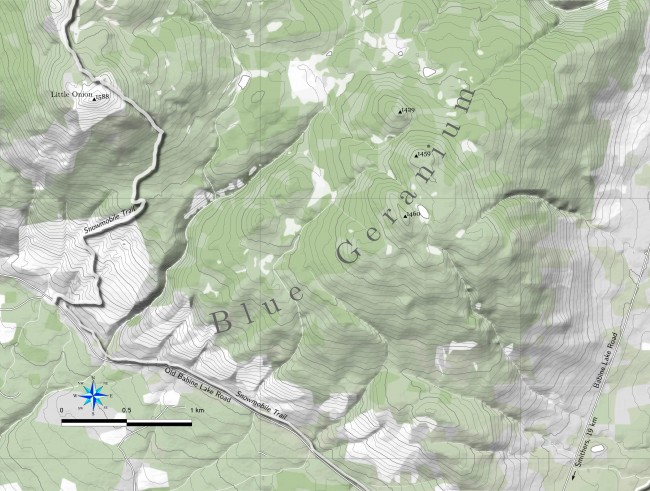
A trail can be a barrier to perceiving place. It focuses our attention on a certain pre-ordained corridor. Like a pipeline, it channels us, and our experience. For this reason the Friends of Blue Geranium (FBG) are advancing an idea for a small snowshoeing area near the junction of Old Babine Road and new Babine Road. Although they’ve been exploring this area for several winters, they’re not flagging trails.
“The purpose of FBG,” says Ray Chipeniuk, a founding member, “is to encourage outdoor recreation which is predominantly about encountering natural things, rather than human artifacts or social interaction.”
Of course off-trail exploration is not for everyone. The amount of attention one has to pay is not just double, but perhaps 10 times more. Every contour of landscape, every slight change in forest—an oddly-shaped tree, the presence of a stream—all need to be noted and assembled into a larger coherent picture, merely so you can find your way back. These are advanced skills, not for beginning hikers, who may find just staying on a trail challenging. It is the hiker completely comfortable with the flagged route, one who perhaps finds the trail no longer wakes her up, who may want to jump out of the pipeline and begin looking at the landscape in a different way.
There are more questions FBG would like to pose. How do large groups affect our experience of place? What’s the effect of intending to get to a certain destination? What are the ethics around flagging or publicizing your route—and how does this change the experience for those who come next? In what way do dogs joining a hiking excursion alter the experience? If you assign names to meadows, lakes, streams and peaks, what are you taking away from people who come later? When we set up a trailhead, how does that distort the landscape in people’s minds? If we are flagging a route, are we doing it just so we can get somewhere else faster? If our culture builds too many roads, is it possible we are also building too many trails?
If these kinds of questions strike a chord, FBG would like to hear from you (send an email to chipeniuk@xplornet.com). FBG members are, as well, happy to accompany you out on a first Blue Geranium trip. It bears saying: away from trails, it is quite easy to get lost!
Practising these ethics is purely voluntary. The Blue Geranium area is not a special reserve, or a piece of land with some kind of special designation. It’s just a typical piece of public land with evidence of old logging and bulldozer use. The idea is to explore the Idea.
For all these reasons, the map here has no trail on it, no trailhead and no feature names. Blue Geranium itself has no actual boundaries. It lacks all those handrails we are used to. It is supposed to provoke a bit of discomfort. Where do I start? Ah...


