Photo Credit: Map by Morgan Hite. More maps at bvtrailmaps.ca
Hankin Lookout Cabin Sleeping in the sky Morgan Hite
A boxy, renovated two-story fire lookout sticks up on a knob on the north side of Hankin Peak, with fine views of Rocky Ridge and the Kitseguecla River valley, as well as Ashman Ridge and Paleo Peak to the west. It sports a fine, old, table-mounted optical sight used by fire-spotters, and you can bring your sleeping bag and camp stove and spend the night inside. Reading the register, you will learn that people come here as often in the winter (on skis) as in the summer, and that many parents have brought children despite the steep trail. Well-behaved dogs are also welcome. Please pack out all your trash.
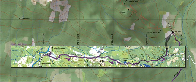
From Highway 16, 6 km south of Moricetown and 25 km north of Smithers, turn west on Kitseguecla Lake Road. (This turn is well signed with a green-and-white “Hankin-Evelyn Backcountry Recreation Site.”) Cross the railway tracks and stay on Kitseguecla Lake Road, ignoring a second green and white Hankin-Evelyn sign at about KM 8 that indicates that you should turn left. At kilometre 13, you’ll find Taltzen Lake on your left, and a turn for Kitseguecla Lake on your right. Continue straight, but – and this is the crucial bit – at an unsigned intersection 1.5 km farther on, turn left. If you go straight instead, you’ll soon see the 6017-kilometre marker, and that’s confirmation you’re on the wrong road.
After that turn the road has some really impressive potholes, so drive carefully. About 5.5 km farther the road again splits and there are signs directing you to bear left. The parking area is 1 km farther. Thanks to a particularly difficult pothole in this last kilometre, a regular low-clearance vehicle can only make it to the trailhead if the driver is especially skilled—or is willing to ground out a few times, as I did.
The trail is well signed from the parking area. It initially continues along the road you’ve been driving, but it soon turns abruptly to the left, heading up through an old cutblock. After about 10 minutes you’ll enter a very attractive uncut hemlock forest and begin ascending steeply. The trail is easy to see on the ground, and is well marked with orange reflectors and tape. Some parts are steep, and some are... umm... a bit less steep. As you approach the cabin (about 75 minutes later, having climbed about 500m over 2 km) you will first encounter a small meadow, then cross a small stream, and finally ascend a last steep section that includes a gully of loose stones.
Don’t expect a log building: this cabin is a cubical structure whose upstairs room has glass all around. There is a double-bed-sized platform in there (blue insulation foam over plywood) and, if you descend the ladder or go around to the lower door, three more platforms and a wood stove. There’s wood in the shed around back—flown in by helicopter for stove use only, so please don’t build any outdoor fires. The lightning rods on the roof and the steel cables holding the building down suggest it’s an exciting place in a storm!
The water source for the cabin is that stream you crossed on the trail about 8 minutes before getting here. Outside the cabin is an outhouse down a short trail to the northeast. And the trail you came up continues on, reaching treeline on Hankin Peak in about 30 minutes.


