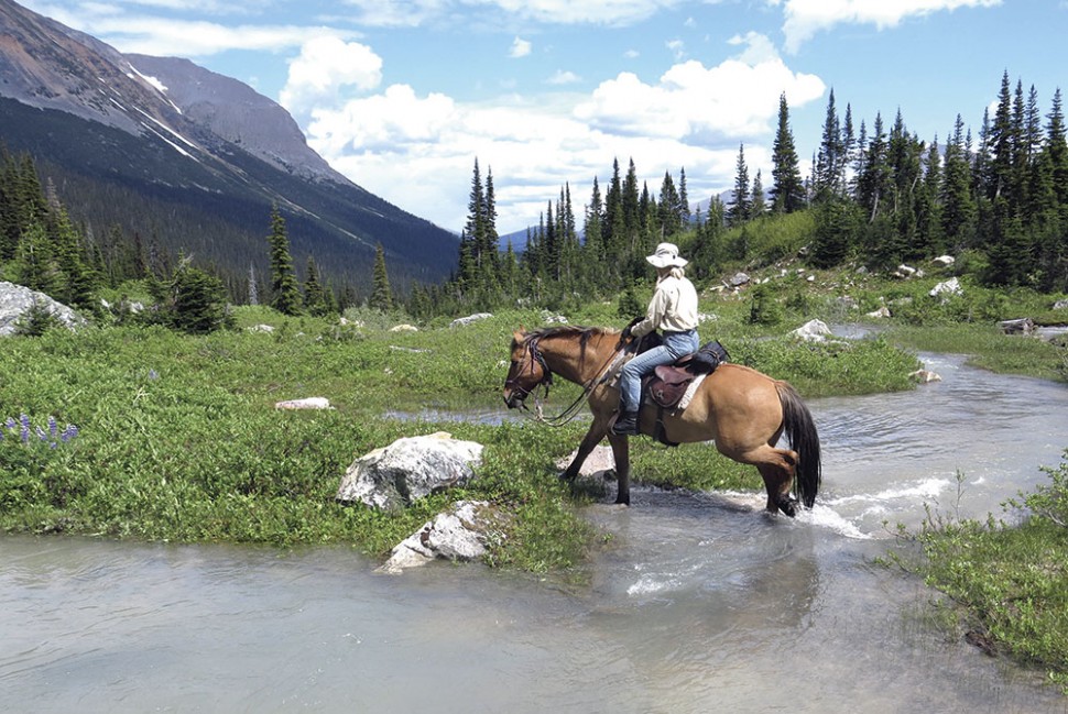
Photo Credit: Photo Peggy Snowden
Kakwa by Horse: Region offers Banff’s beauty without the multitudes
Squish, slop, squelch. Blech. Three of us and our six horses were traversing a former mining road into Kakwa Provincial Park for a two-week horse pack trip. After two days of rain, the “road” had been transformed into a morass of clay mud and both horses and riders were soaked through.
But a bit of mud wasn’t going to dampen my enthusiasm. Horse pack trips are always an adventure and Kakwa is truly unique. Imagine the over-loved Bow Valley area of Banff National Park with no roads, minimal trails and few people. Now add dinosaur tracks, grizzlies, the Mount Sir Alexander massif and access to the Continental Divide. Welcome to horse-pack-trip paradise.
Kakwa Provincial Park is located approximately 70 km northwest of McBride and is bounded to the east and southeast by the Continental Divide—which is also the BC-Alberta provincial boundary. Kakwa Wildlands Park and Willmore Wilderness Park are located in Alberta immediately east and southeast of the park, and together the three parks form Kakwa-Willmore Interprovincial Park. The southeast corner of Kakwa Provincial Park is the top of Intersection Mountain—so named because the peak is situated exactly at the junction of 120 degrees west longitude and the Continental Divide.
Although motorized travel is generally prohibited in the park, snowmobiles are permitted in winter. Hence, while the park is essentially bereft of summer visitors, it is a highly popular snowmobiling area. Publicly accessible huts are located at Kakwa and Jarvis lakes. Informal camping is permitted throughout the park.
Permission from BC Parks is required to travel with horses in Kakwa Provincial Park. Regardless of your planned mode of transportation, check with Parks before your trip regarding access road conditions (which vary significantly from year to year), bear and porcupine concerns, plus current regulations for publicly accessible cabins and park fees. For explorers venturing into neighbouring Willmore Wilderness Park, contact Willmore Wilderness Foundation in Grand Cache for trail updates.
Packers’ paradise
The scenery in Kakwa Provincial Park is dominated by the Mount Sir Alexander massif (named after Alexander Mackenzie), which soars to 3,270 m. The lakes and easily accessible subalpine and alpine areas are an explorers’ paradise.
Kakwa is a Cree word for porcupine, which are ubiquitous in the park, and archaeological evidence suggests that the area was historically used by First Nations people. The earliest expedition record into the Kakwa area was in 1875 when E.W. Jarvis and C.F. Hanington crossed Jarvis Pass in what is now Kakwa Provincial Park while searching for a railway route through the Rockies. In 1877, George Dawson indicated “unexplored region” on his map of the area southeast of Pine Pass (located northeast of Prince George).
In 1909, the top of unnamed Mount Sir Alexander was seen in the far distance by a mountaineering party on Mount Robson. The so-called Big Mountain subsequently became a sought-after objective by explorers and mountaineers of the day. In 1912, Samuel Prescott Fay—a hunter-scientist-explorer—reached Kakwa Lake, but did not have time to explore the Big Mountain. However, in 1914, during a grand five-month journey from Jasper to the Peace River and back to Edson, Fay explored the Kakwa region as well as the massif that he subsequently named Mount Sir Alexander.
Through the first half of the 20th century, the remote location and special scenery of Mount Sir Alexander and surrounding area drew hunters, scientists, mountaineers and tourist pack-trippers to the area. With the decline of horse-pack tripping after World War II, the Kakwa area was forgotten by all but a handful of trappers and hunters.
In the late 1970s, Ken Farquharson—an environmental consultant known for his conservation efforts—flew over the Kakwa area in a helicopter while returning from a trip to Tumbler Ridge and was entranced by the exceptional scenery. He subsequently alerted BC Parks to the area’s qualities, and in 1987 Kakwa Recreational Area was born. Due to the potential for a quartzite quarry within the recreational area, Kakwa did not become a Class A provincial park until 1999.
In 2000, hunters in the park’s northern portion discovered dinosaur tracks across steep alpine rock faces. The discovery led to many years of paleontology research, the results of which are displayed at the Tumbler Ridge Dinosaur Discovery Gallery. The story of the site’s discovery and subsequent struggle for control between amateur and professional “dinosaur chasers” is told by Vivien Lougheed in Sidetracked: The Struggle For BC’s Fossils (Creekstone Press, 2011).
Deterred but not defeated
There are no roads into Kakwa Provincial Park; however, there is an old—and becoming overgrown—tote (mining) road that traverses the park from the McGregor River area in the south to Kakwa Wildlands Park in Alberta. This was the road that we slopped along. Our route took us to Kakwa Lake—surely one of the Rockies’ gems—where we camped for the duration of our trip. We’d planned to ride up onto the Continental Divide, but after three days of sunshine, the weather turned and seemingly endless rain ensued. Prior to our trip, the weather forecast looked promising, but the massive mountains that the park is known for create their own weather.
During the brief sunny spell, we spent a day drying out sopping-wet gear and resting the horses, while a second day was spent riding up to the former quarry. From the horse campsite at the south end of Kakwa Lake, we followed the tote road north along the west side of Kakwa Lake then turned west up a side valley to the subalpine. A variety of wildflowers and stunning views of colourful Babette Lake made lunch a memorable affair. The return trip was easy, although fresh bear tracks along our trail—in an area well known for grizzly—were disconcerting.
On what would be (unbeknownst to us) the last of our sunny days, I rode solo to the east toward Broadview Lake to find a trail for our planned trip along the Divide. The trail was muddy, with many trees down, but generally easy to follow. As the clouds re-appeared, I turned and rode back to camp just in time for the next storm. It was a doozy, and after many soakings, no scenic views, sodden grazing areas and an inability to continue our trip onto the Divide, it chased us home.
However, Kakwa still beckons. I’ve yet to see the Mount Sir Alexander massif as it was covered in cloud the entire trip. Additionally, the remote, horse-friendly, mountainous country along the Continental Divide is a major drawing card, along with routes and trails that extend to Mount Robson Provincial Park, Jasper National Park and Willmore Wilderness Park.
For keen explorers, Kakwa is one of those special areas it’s hard to believe still exists. It’s remote, under-discovered by summer visitors, and gets under the skin of those who are fortunate to experience its wonders: definitely worth the trip.


