Photo Credit: Morgan Hite. More maps at bvtrailmaps.ca
McDonell Lake Trail
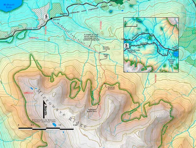
The McDonell Lake Trail is an old horse-packing route that historically began at the lake, opposite Copper River Ranch. Presumably, hunting guide Lefty Gardiner built it to access the alpine areas on the ridge due south (commonly called Microwave Ridge today). Today, road access is from the McDonell West Forest Service Road, about a kilometre from the lakeshore at 900 m elevation.
To reach the trailhead, follow Hudson Bay Mountain Road from Smithers as if driving to the downhill ski area, but turn left on McDonell Lake FSR at 13.7 km. Follow this resource road for another 13.8 km and, just after Dennis Lake Rec Site, turn left at a sign for McDonell South FSR.
This stub of a forest service road runs over a bridge (the nascent Zymoetz River) and comes to a dead end after 1.2 km. Here, the McDonell West FSR begins: turn right and drive about nine kilometres. Be careful to turn left at 3.6 km where, if you go straight, active logging is occurring. Just past the 9-km marker, the trailhead is on the left and a small parking area is on the right. If you cross a single-lane bridge, you’ve gone too far. All told, since the roads get slower and slower as you approach the trailhead, it’s about an hour’s drive from Smithers.
For the first two kilometres the trail ascends gently through mossy spruce-fir forest and you can hear an unnamed stream rushing along to your right. About an hour into the hike this section ends as the trail suddenly turns right, descends and crosses the creek. (Is it just me or does the stream’s noisy grumbling seem to produce bass notes from upstream and treble notes from downstream?)
Now the trail ascends more steeply: first through a boggy section to the base of the mountain and then right up the side of the ridge. Cresting at about 1380 m, just as the trees are getting smaller and views begin to appear, it takes an unexpected dive down (this can be a shock—prepare yourself to give up some of the elevation you’ve gained) to return to the forest and gain the centre of the drainage. Perhaps this was done to keep the trail in the trees as long as possible, to give cover in bad weather. The trail now crosses a few small creeks and ascends what passes for treeline here: a parkland of alternating copses and clearings with great views. All told, it is just over two hours to this point. In early summer there is a lot of water available.
You are now in an alpine basin that opens to the north. You can enjoy a stunning and unusual view of Brian Boru towering beyond the rounded Hankin Peak. There is also the interesting feature of the layered volcanic rocks on the ridge that bounds the basin on the east. The top of Microwave Ridge can be reached by continuing south on the trail, which leads toward the col at its southeast corner and then up onto the main ridge.


