Seaton Ridge trail: A high lookout upon many ranges
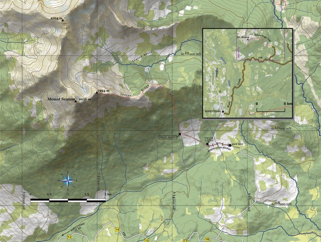
As you drive into Moricetown from the south you can’t help but notice the prominent peak that seems to stand just behind the town. It received the “official” name of Mount Seaton in the 1950s, in connection with a small CNR station named “Seaton” below it—but surely it had an older, Wet’suwet’en name. At 2,036 m, it offers superb views down into the Seaton Basin behind it, out to local ranges (Rocher Deboule, Hudson Bay, Telkwa, Babine, Goat and Blunt) and beyond to distant peaks like the Hogem Range 100 km to the east, and Paleo Peak 50 km to the west, with the massive Mt. Sir Robert looming behind.
The Seaton Ridge trail will not get you to the summit of Seaton itself, but to an adjacent peak just to the east, at 1,994m. Below, I’ll get into what happens if you want to make the final traverse to the peak with the name.
Finding the trailhead is straightforward, but don’t expect signs leading the way. Begin by turning onto the Telkwa High Road at Moricetown, crossing the bridge over the Bulkey and wending your way to the top of the hill. Here, bear left on the Blunt Creek Forest Service Road, and drive 18 kilometres. The turn that you want off the Blunt Creek FSR is a side road to the left, unsigned, coming just after the 18 km marker (“2018”). This road is in good shape and does not require a high-clearance vehicle.
The parking area (also unsigned) is about 3.5 km along this road, where the road abruptly stops at the first of a series of de-activation ditches. (When driving in, turn left at the only significant fork, after about 1.5 km.) Have faith, park, and continue along the road on foot. After about 600m there is a sign, “Trail,” directing you right at a fork. Where the track reaches the far side of the cutblock there is another sign (“Mount Seaton”) and now the trail turns straight uphill, paralleling a small stream.
At treeline, after about 90 minutes of steady climbing, the trail turns west to run along the top of the ridge. There’s a lot to see, both north into Seaton Basin and south to the Babines. The ridge rises gently for the first kilometre, and then steeply for the second, bringing you to the top of the unnamed prominence (1,994m) with a superb panorama. Along this last kilometre are a few rocky knobs which can sometimes be passed on the south slope, but do not attempt to by-pass the final prominence unless you want to get into some very dicey rock.
Mount Seaton proper is yet one more kilometre along the ridge, but getting there is fairly challenging. The tricky bits are the steep, scree-filled gullies and sharp fins of really rotten rock at the low point connecting the two. They are harrowing to negotiate. If the phrase “sketchy 3rd classing through lousy rock with significant rockfall hazard” doesn’t mean much to you, this is probably not where you want to go.
Allow about 3 hours up and 2 hours down. After the trail wanders away from the small stream near the cutblock, there’s no reliable water.


Hey I was looking at this, I believe this was named from my grand father Henry Massey Seaton who lived and worked that rail line. Seaton Station
👤 George Seaton 🕔 Apr 22, 2017