Photo Credit: Morgan Hite • more maps at bvtrailmaps.ca
Silverking Basin: Winter cabin in the mountains
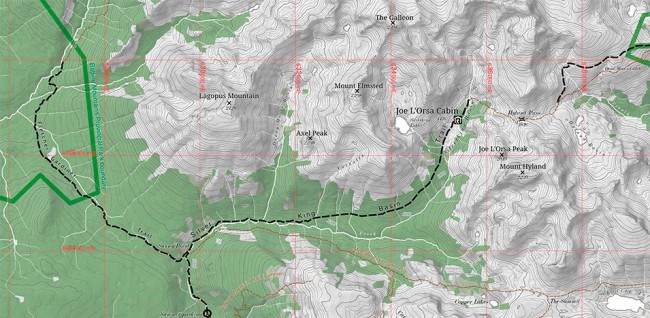
One of the most popular summer hikes near Smithers is the Silverking Basin. Prospectors who tried to make a go of a silver lode from the 1920s to 1980s left an old track that leads to this lovely valley cut deep into the Babine Mountains. Today, the provincial park provides horse corrals and a two-storey log cabin where you can stay for $5 a night. Even in winter hardy travellers can go in there, on skis or snowshoes, and enjoy the cabin’s cozy ambience and firewood supply.
The Joe L’Orsa Cabin is named after the man who led the campaign to create the park, which he proposed in 1973, suggesting it include all the land in the Babines above 1300 m. This was the idea of the celebrated BC conservationist Ric Careless, who told L’Orsa that it might help bring Smithers’ Pacific Inland Resources (PIR) mill—which might otherwise be opposed to the designation of a park—onside, timber above this elevation not being so valuable in those days. Both mining and forestry representatives on the Community Resources Board had to sign off on the park boundaries; it was in this process that the Cronin Mine site and the Big Onion were removed from the planned park and, in compensation, other areas added.
The Babine Mountains Provincial Park was approved by cabinet in April 1998 as part of the local Land and Resource Management Plan, a document that still guides public land use in the valley. Sadly, L’Orsa died a year later, in April 1999, just before the park was officially designated in June. The new cabin was constructed and named for him, and PIR paid for a lot of it.
In summer, the cabin is an 8.5-km hike from the main trailhead at the end of Driftwood Road, some 20 km from Smithers. However, in winter the road is only plowed as far as the park boundary, so your ski or snowshoe is 13.5 km. It is, admittedly, a bit of a slog as you pull your gear behind you on a sled (expect it to take about five and a half hours), so spend a couple nights to make it worthwhile. The route is very gradual, rising only 600 metres in that 13.5 km and the big advantage of skiing in, rather than using snowshoes, is that coming out is a relatively quick downhill coast.
The trail is not entirely free from avalanche risk. In the last 1.5 km, the old road emerges from the forest and passes under open slopes. The risk here can be easily managed, avoiding the slide paths by looping out into the meadow. However, you should be educated about avalanche terrain and managing risk while travelling in such terrain, and check avalanche conditions before you go at the Canadian Avalanche Centre (avalanche.ca). Also note that the avalanche risk in the terrain beyond the cabin gets serious in a hurry.
The cabin has a wood stove (and a copious supply of firewood in the shed out back, although be prepared to buck it yourself with a handsaw). It sleeps up to 20 on a first-come, first-served basis. Bring your own stove and cook on the metal-covered counters. You can melt snow for water, but at times it’s also possible to chop a hole in the ice on the creek out back. Smoking and alcohol are not permitted.
The route into Silverking Basin is gradual, rising only 600 metres in 13.5 km, making the ski out a relatively quick downhill coast.


