The Silvern Lakes
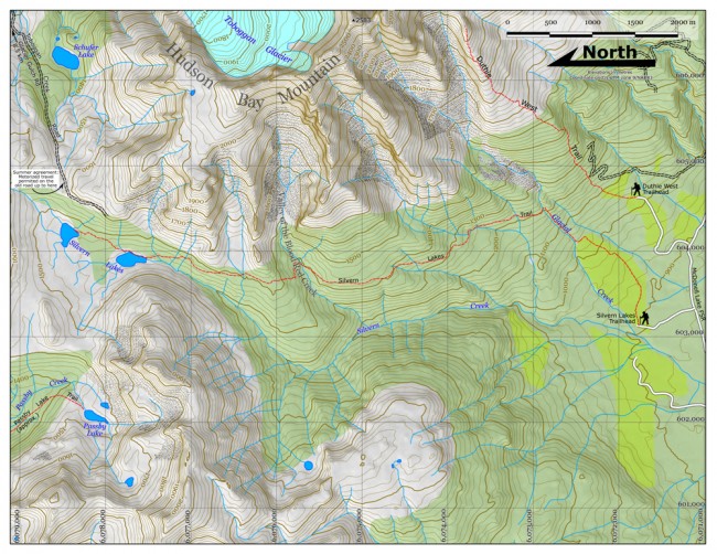
This is an intriguing trail that takes one deep into the area behind (that is, to the west of) Hudson Bay Mountain near Smithers. Three mountain groups meet there (Hudson Bay, the Evelyn-Elliot group, and the Turquoise Range, and in the high area at the centre, around treeline, are the two Silvern Lakes.
The trailhead is a bit obscure. Just before kilometre 10 on the McDonell FSR you’ll see a brown sign on the right for the Silvern Lakes Trail. Turn here and follow a dirt track, thinking to yourself this can’t be right: it’s in such bad shape! After 800 metres the track forks, and a small brown sign saying “Trail” indicates the fork to the right. Park here.
You’re at 900 metres elevation now, and it’s about a three hour hike to the lakes. Each hour has its own distinctive character.
The Hour Of The Grunt begins by knocking back the rest of your coffee, and following an old road through an old cutblock for 1 km (cross a stream right away: wide but shallow). This takes you up 70 metres. The trail then takes over, and continues up through a replanted area (six-metre-tall pines close by on either side) for another 0.5 km and rising 70 more metres. Entering uncut forest, it heads straight up-slope, paralleling Glacial Creek to the left (below in a gorge: noisy, foaming, entirely aesthetic) for another 0.5 km and another 150 metres climbed. Here you meet the old and original trail coming in from the right. Turn left on it and cross Glacial Creek. You’re now at 1215 m. Whew!
The Hour Of Going Back In Time is next, and involves following this mellow trail north through the forest, contouring around the back of Hudson Bay Mountain. Although constructed with hand tools close to a century ago, the grade is even and shallow, giving you an easy walk of just over 3 km. There are no views to speak of, but it’s worth keeping an eye out for signs of the old days, like old cans, bottles and other remnants of prospectors’ life.
The Hour Of Thrills begins when, now at 1440 metres elevation, you enter the Red Valley, and get a good view of the buttresses that form the back of Hudson Bay Mountain. Cliffs at the head of the valley host the red-purple rock that colours the bed of the creek you are about to descend and cross. Beyond the crossing, the trail ascends, and after the dull grade of the last hour this bit is a serious thriller: sustained, steep and switchbacked, the trail screams up over a forested ridge (+ 100 metres) for 0.75 km. Then it’s a gradual descent of 1.5 km, through increasingly short and patchy trees, with views of more cliffs and buttresses, as well as unnamed peaks to the west. The first Silvern Lake is at 1440 metres elevation; it’s 15 minutes up to the next lake, 40 metres higher.
The landscape up here is wet transition-treeline: no nice meadows, but clumps of trees interspersed with open, sometimes boggy areas. The peaks to the west (unnamed), north (Elliot) and east (Hudson Bay) look fantastic to explore. As well, one can follow traces of a trail from the second lake, up towards the pass, to find the Toboggan Creek Road, and thereby return to Smithers at Glacier Gulch Road (about ten more kilometres, mostly descent).
Returning back down the Silvern Lakes Trail takes about two hours and 45 minutes.


