Photo Credit: Photo Lyle Daly
Wolverine Range: Unexplored terrain, unparalleled views and untamed canines
Last August, a helicopter picked up nine hikers, mostly seniors and all members of the Prince George Caledonia Ramblers, from Germansen Landing, 219 km north of Fort St. James. It carried us to an alpine tarn nestled under imposing ridges to start our week-long hike in the Wolverine Range, which runs 50 km lengthwise between the western shore of Williston Lake and the Omineca River.
Dave King, who had led us on Kakwa and Mount Edziza hikes in recent years, had asked Germansen Landing storeowner Lynae Muller, whose family had lived there for generations, if they had ever been up in the Wolverine: “No,” she replied. “In fact we don’t know anyone who has ever just gone hiking up there.”
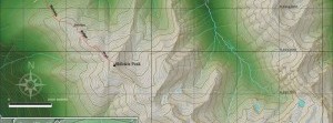
Our backpacking route would take us 65 km south from this alpine lake along ridges toward Manson Creek. With no trails, and most of the hike in the alpine, we relied on topographical maps and GPS. As rain and near-freezing temperatures the first couple days gave way to mostly T-shirt-and-shorts weather, crossing valleys involved bushwhacking through shoulder-high alpine fir.
Big days and bigger views
The Wolverine Range sits in the Omineca Provincial Park and Protected Area, which was designated in 2001 and contains historic mining sites from the Omineca Gold Rush, as well as extensive opportunity for wilderness recreation. The park provides habitat for caribou, moose, goat, wolverine and aquatic mammals. The Omineca River also provides important habitat for red-listed arctic grayling.
The ridge above our first camp offered an expansive view of Williston Lake. We were directly opposite the Peace Arm with the Parsnip Arm extending to the south, the Finlay to the north and the Omineca spilling into the lake below us. Just a little to the northeast was the Ospika Arm. We could see it all from our vantage point, surrounded by rocky ridges folding away in each direction. We overlooked where Finlay Forks once existed, now submerged beneath manmade Williston Lake.
We were up at 6:30 a.m. most days and on the trail by 8 a.m., where we saw ptarmigan, one hummingbird and several marmots. There were no signs of bear, but several caribou sheds and goat droppings. Some days involved a considerable amount of climbing up and down through sub-alpine growth. It is easy to trip and fall on hidden rocks and roots, but almost impossible to get back up with a 30-pound pack on your back and your head hanging downhill—it was always good to have a helping hand out of the predicament. We clambered over rocky side-hills and by the time we found a suitable alpine lake each night with a nice grassy patch to camp, we were usually exhausted.
Smoke signals and steep ascents
The summer had been unusually dry with above-average temperatures and while resting for lunch one day we noticed a plume of dark smoke rise above Williston Lake down the Peace Arm. It grew at an alarming rate, billowing into mushrooms of white smoke; then we saw another fire farther northeast. While the fires didn’t endanger us, the smoke limited views and we only used camp stoves for cooking.
During one long day’s hike, we doffed our packs to climb Mount Porter, at 2,100 m the highest point on our trek. A cairn marks the peak, so it was obviously not a first ascent, but there were no trails or other signs of human life. From the top, the distinctive rolling ranges of the Omineca Mountains spread out around us.
But Mount Porter didn’t present our most challenging day. That came on a day of steep climbs, vertical drops and long ridge traverses. Ahead lay a cliff and Dave King, our six-foot-plus leader, tested it by reaching for distant foot- and handholds while the rest of us discussed how we would get help in an emergency. He returned safely, saying, “No problem, you’ll all manage it fine.” He was so confident that he’d left his brush-cutter and pack at the top.
What he didn’t know was that a couple of members were quaking in their boots and had decided, There’s no way we’re going up there! The group split, one half descending to a lake below and then climbing up to the saddle while three of us followed King, finding our way down sheer rock before starting the ascent. As we climbed, we clung to the rock along a narrow ledge with a precipitous drop below, reaching for tentative foot- and handholds up a steep chimney. King helped us up the last steep pitch with a much-needed strong arm. It was a great feeling as we reached the top with a fabulous view of the next long ridge. We re-united with the rest of the group at the saddle and continued traversing before climbing up the final ridge.
Perturbed pooch in paradise
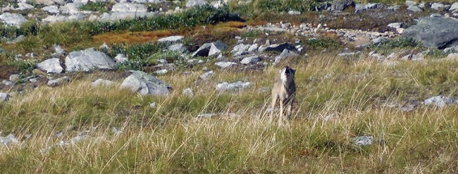
One thing we weren’t expecting in this untravelled terrain was the sound of a barking dog. We were amazed to see a large, grey wolf vocalizing its discontent at three group members perched on a rock below us. The stragglers watched as it emerged from a rock outcrop toward them. Standing aggressively, it continued to bark with an occasional howl to prove that it was, in fact, a wolf, eventually loping away as the hikers donned their packs and continued. We presume it was protecting its young, hidden in the rocks behind.
Beyond our vantage point on the ridge were two beautiful lakes where we set up our tents and enjoyed a much-needed alpine bath and change of clothes. A family of ptarmigan walked right into our camp before being silhouetted on the rock. That night we watched russet alpenglow dance on the mountains.
The final day, we descended over windfall to a clear cut, which had grown up over our heads. It took four hours to walk four km and a total of 12 km to get out to the road. We camped that night at Wolverine Lake, a pretty spot close to Manson Creek.
We returned home by a different route, via the Finlay Forest Service Road, to Highway 97 just north of McLeod Lake then to Prince George, all agreeing that although it was a tough hike, we were now stronger and fitter and it had been exciting to explore a new area.


Hello your trip sounds wonderful me and my friend hiked those ranges last year right after your group in the middle Of September we did both peaks as your looking head on from wolverine lake we quaded around to the right side an bushed whacked through a clear cut then reached the stream running at the base started from there it was by far the most strenuous hike I’ve ever done but one of the most spectacular we did it in one day both peaks I wanted to drop dead after the first peak I was exhausted but my friend kept pushing me saying I would have been the youngest to ever reach the top I was wearing gumboots and jeans once I got to the very top it was definitely worth it amazing on the way back we missed placed the quads because the clear cut brush was taller than are heads at that point I couldn’t keep up and my legs kept giving out so we lost each other but after half hour we found each other again by calling to each other it was quite the adventure
My friend tho has done the sister peaks behind the range we did towards the right
👤 Chalaine snyder 🕔 Aug 09, 2015